
Dust storm warning issued throughout Valley Sunday evening, as thunderstorms also approach
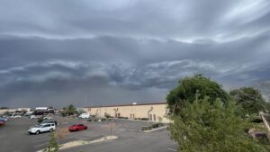
The National Weather Service in Phoenix issued a dust storm warning for Maricopa County until 8:45 p.m. Sunday.


The National Weather Service in Phoenix issued a dust storm warning for Maricopa County until 8:45 p.m. Sunday. (NWS photo)
(NWS photo)
It is monsoon season, and a large plume of dust traveling along State Route 202 caused officials to issue a dust storm warning on Sunday evening.
A Dust Storm Warning is in place for the west side of the Phoenix metro. A large plume of dust is progressing northward over/west of South Mountain and along SR 202. Near zero visiblity and wind gusts up to 40 mph are being observed. Pull aside to stay alive! #azwx pic.twitter.com/DyraEVcOFM
— NWS Phoenix (@NWSPhoenix) July 13, 2026
The National Weather Service in Phoenix issued the warning for Maricopa County until 8:45 p.m. Sunday.
NWS said the wall of dust was moving northwest at 30 mph from Sun Lakes to Estrella Sailport to Big Horn. The advisory warned visibility will drop to under a quarter mile with winds moving at more than 40 mph.
Drivers are advised to avoid dust storms, if possible, but they should pull off the road, turn off their lights and keep their foot off the brake if they are caught in one.
A dust storm warning is in effect until 8:45 PM MST for I-10 near Avondale–Goodyear, AZ and I-10, I-17, US-60 near Phoenix–Mesa, AZ. pic.twitter.com/GJm4CREqCS
— NWS Phoenix (@NWSPhoenix) July 13, 2026
Earlier Sunday, NWS had Phoenix, Mesa and southeast Arizona toward the Mexico border at a slight risk threat assessment for Sunday afternoon into the evening.
Thunderstorms are expected to develop again this afternoon across the AZ high terrain and push into the lower deserts by early this evening. Not everyone will see rainfall with only about 20-30% coverage across the Phoenix Metro. A few storms could be strong to severe. #azwx pic.twitter.com/E224wLHfPh
— NWS Phoenix (@NWSPhoenix) July 12, 2026
Storms are expected to develop over higher terrain and in southern Arizona, which could produce damaging winds and dense blowing dust in outflow boundaries.
There is a 30-50% chance of storms in lower-elevation communities.
Weather forces ground stoppage at Sky Harbor International Airport
A ground stoppage was issued for Sky Harbor International Airport by the FAA, due to the storms. As of 8:45 p.m., nearly 400 flights were delayed at Sky Harbor on Sunday.
Weekend weather alerts
NWS also issued a severe thunderstorm watch until 10 p.m. Sunday for Maricopa, Gila, Pinal, Pima, Santa Cruz and Yavapai counties.
A severe thunderstorm watch has been issued for parts of Arizona until 9 PM MST pic.twitter.com/gzhKlzH2th
— NWS Phoenix (@NWSPhoenix) July 12, 2026
Sunday’s alerts came after NWS Phoenix issued a dust advisory for Saturday evening from 6 p.m. to 10 p.m., as clusters of strong storms southeast of Phoenix brought strong winds and affected visibility in the southeast Valley.
“(The Dust Advisory) is due to some thunderstorm activity starting in our south, mostly in Tucson area, but that might generate an outflow that pushes dust into our zone,” NWS Phoenix meteorologist Alicia Ryan told KTAR News 92.3 FM Saturday morning.
NWS issued a severe thunderstorm watch for southeast Arizona, including Pinal County, Saturday afternoon from 3:45 p.m. to 10 p.m.
Dense blowing dust and severe straight-line wind gusts were the primary hazards, authorities said.
Wind gusts exceeded 20 mph, clouding the skies and decreasing visibility.
Dust has moved into the southeast Valley. This is in the Chandler area. A Dust Advisory has been issued for the southeast Valley. The outflow boundary is starting to slow down, but gusts over 20 mph and dusty skies are still expected. #azwx pic.twitter.com/jK254fPj4v
— NWS Phoenix (@NWSPhoenix) July 12, 2026
Anyone driving on Interstate 10 and I-8 in Gila Bend, Maricopa, Queen Creek to the Valley and south of the Phoenix metropolitan area is encouraged to pull over if they experience dense blowing dust.
Going from Sunday into the new week, Ryan said the storm activity is expected to bring humidity to the Valley and south of it.
“With the increase in moisture, we are expecting dew points to be in the upper-50s, mid-60s, at the highest mid-60s,” Ryan said. “That will kind of lead to that kind of stickier feeling, especially in the mornings, after we do get that rain in the overnight period. Those following mornings will feel particularly more humid.”
KTAR News 92.3 FM’s Douglas Santo contributed to this report.
Related
 Construction projects close lanes on 3 Phoenix freeways this weekend
 Phoenix events calendar: Things to do this weekend and beyond
 Arizona, Southwest record hottest first half of year in 131 years, weather service says
 Storms bring scattered showers, dust to Valley causing delays at Sky Harbor and power outages
 Scattered showers, thunderstorms expected to hit metro Phoenix
 Get ready for rain! Phoenix could see its last 100-degree day before weekend storms

Comments
0 Comments