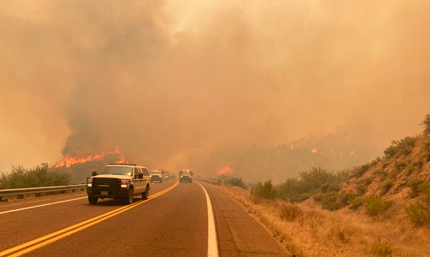
Bush Fire keeps growing northeast of Phoenix area to nearly 115,000 acres
Jun 18, 2020, 8:12 AM | Updated: 4:04 pm
(Twitter Photo/@azstateforestry)
(Twitter Photo/@azstateforestry)

PHOENIX – Evacuation orders were issued Thursday as the massive Bush Fire northeast of metro Phoenix continues to grow.
The communities of Brownsville, Jake’s Corner, Slate Creek and Pioneer Pass were ordered to evacuate at 3:45 p.m. by Gila County officials.
By Thursday morning the fire had consumed nearly 115,00 acres, authorities said.
The blaze eating up tall grasses and brush in Tonto National Forest was 5% contained. No structure damage or injuries have been reported.
The fire has been thriving on a combination of high temperatures, winds up to 30 mph and an abundance of dry vegetation.
At 114,941 acres, the Bush Fire is the seventh-largest wildfire in Arizona history, according to KTAR News 92.3 FM research. No. 6 on the list is the Willow Fire, which consumed 119,500 acres southwest of Payson in 2004.
Hundreds of residents in the nearby Apache Lake, Sunflower, Punkin Center and Tonto Basin communities have been evacuated.
The communities of Jakes Corner, Gisela, Rye, Deer Creek and Bar T Bar Ranch have been placed on alert for potential evacuations.
RELATED STORIES


The American Red Cross has opened evacuation centers at the Payson Police Department and Lee Kornegay Intermediate School in Miami.
Wednesday afternoon, Southwest Area Type 1 Incident Management Team led by Alan Sinclair had been assigned to combat the blaze.
Sinclair and his team had recently worked to help contain the Sawtooth Fire in the Superstition Mountains.
More than 200,000 acres of private, federal and tribal land in Arizona have been burned by nearly 1,000 fires this year, and officials said 95 percent of the blazes were caused by humans. They said that while most weren’t intentional, they were preventable.
The Bush Fire was sparked by a vehicle fire on June 13.
Multiple roads around and through the area of the fire remained closed:
- State Route 87 between the Bush Highway and Payson.
- SR 188 between SR 87 and Roosevelt Lake.
- SR 88 between Apache Lake and SR 188. (The long-term closure of SR 88 east of Tortilla Flat to Apache Lake means vehicles can’t travel east of Tortilla Flat on SR 88).
The following recreation areas in the vicinity also are closed: Sugarloaf, Four Peaks, Lower Sycamore, Pobrecito, Butcher Jones, the Rolls, Saguaro Del Norte Recreation Areas and Saguaro Lake.
KTAR News 92.3 FM’s Jim Cross contributed to this report.