
Monsoon storm brings rain to the Valley for second consecutive night
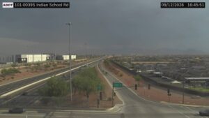
The monsoon season was at it again Thursday as a storm brought widespread rain to the Valley for a second consecutive night.


(ADOT Traffic Camera)
(ADOT Traffic Camera)
PHOENIX — The monsoon season was at it again Thursday as a storm brought widespread rain to the Valley for a second consecutive night.
Some areas in the East Valley near Phoenix-Mesa Gateway Airport recorded about half an inch of rain, according to the Maricopa County Flood Control District rain gauges.
Heavy pockets of precipitation were also measured in the West Valley, Laveen and Ahwatukee.
The East Valley is experiencing heavy rains.
Please:
• Don't tailgate
• Slow down on wet pavement (to avoid spinouts/crashes)
• Don't drive into flooded washes or roads.
Check your route before you head out with the AZ 511 app: https://t.co/MxTvyyEdpM pic.twitter.com/xZOfnR2ZTz
— Arizona DOT (@ArizonaDOT) July 15, 2022
825PM Radar Update: Area of showers & thunderstorms now moving into the Phoenix area. Gusty winds, freq. lightning, and locally heavy rain expected. Isolated strong winds possible. Activity will continue into the early morning hours. #azwx pic.twitter.com/4835ANGPCi
— NWS Phoenix (@NWSPhoenix) July 15, 2022
The downpour came about 24 hours after a Wednesday night storm forced the closure of U.S. 60 near Val Vista Drive and Gilbert Road for more than three hours as over an inch of rain fell.
The rain cooled off the Valley after a high temperature of 111 degrees was recorded in Phoenix on Thursday, four degrees higher than normal but five degrees short of the record set in 2003.
Storm are possible for the remainder of the week with a 20% chance for rain on Friday, Saturday, Sunday and Monday nights, according to the National Weather Service.
The high temperatures are expected to stay above 110 degrees through the weekend.
An excessive heat warning for the Valley was set for Saturday, when temperatures up to 114 degrees are in the forecast.
Related
 Thunderstorm batters East Valley, results in flooding that closes US 60
 2 people found dead after apparent murder-suicide in Phoenix
 Kiwanis Park celebrating reopening of north play area with free event
 Monsoon activity approaches Valley as thunderstorm warnings issued
 SAFE Alert issued for missing 72-year-old man last seen in Chandler
 Scottsdale ranked as one of the nation’s top places to retire

Comments
0 Comments