
How badly did the Pocket Fire damage land near Sedona? Crews are finding out
With the Pocket Fire mostly contained, crews are studying the burn scar to determine whether storms could cause flooding or erosion near Sedona.


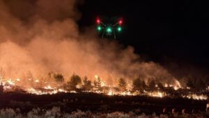
(Forest Service photo via Facebook)
(Forest Service photo via Facebook)
With the Pocket Fire 83% contained, federal crews are shifting from firefighting to assessing what hazards the burn scar could create next.
A U.S. Forest Service Burned Area Emergency Response team, known as BAER, has begun surveying damage on National Forest System lands. The team is looking for post-fire risks such as flooding, erosion and threats to natural and cultural resources.
“What a BAER team does is come in and look at the effects of what the fire did to the landscape,” Dick Fleishman, an information officer with the Pocket Fire BAER team, told KTAR News 92.3 FM on Thursday.
How are crews assessing the damage from the Pocket Fire?
Fleishman said the first step after a wildfire focuses on damage caused by firefighting efforts. That includes repairing dozer and hand lines, improving drainage and chipping vegetation cleared during fire operations.
The BAER process is different. Its goal is to determine how the fire changed the landscape and whether emergency measures are needed.
“Our marching orders are to protect human life, safety, property and critical natural and cultural resources on National Forest System lands,” Fleishman said. “What we’re looking at now is doing the figuring out what’s changed with the soils out there that might actually change how water moves off a landscape.”
The team includes archaeologists, botanists, engineers and wildlife biologists who are studying potential impacts to cultural sites, vegetation, infrastructure and wildlife habitat. Crews are also evaluating whether storms could send more runoff across the burn scar.


The BAER team is comparing satellite data with conditions on the ground before making final conclusions about the fire’s impact.
Fleishman said the team first receives a satellite image known as a Burned Area Reflectance Classification map, which estimates burn severity. Crews then validate that data in the field.
“What we’re seeing initially … a lot of the stuff that was shown as high severity is not as bad as it looks once you start looking at the soils,” he said.
When will the team understand the fire’s impact?
The field work will be used to create a soil burn severity map, which will help hydrologists model how water may move across the burn scar compared with pre-fire conditions.
The team is focusing on three watersheds: West Fork of Oak Creek, Dry Creek and Secret Canyon.
Fleishman said the modeling will help determine how much additional runoff could be generated because of fire-related soil changes. The team expects to have that information ready by late Sunday and will share it with partner agencies, including flood control districts and emergency management officials in Coconino and Yavapai counties.
“So, we share that information with them so they understand … how that’s going to affect their constituents,” Fleishman said. “It’s a science-based process that actually happens really quickly that we actually will have report out by the end of next week back to the forest and make recommendations on how to protect life, property and resources on National Forest System lands.”
When did the Pocket Fire break out?
The Pocket Fire broke out June 19 about 7 miles north of Sedona in the Red Rock-Secret Mountain Wilderness area of Coconino National Forest.
The fire prompted temporary evacuations and challenged firefighters as it spread through rugged, difficult-to-reach terrain.
Several major hurdles were cleared Monday, when State Route 89A reopened in both directions between Sedona and Kachina Village south of Flagstaff, and all areas still under evacuation orders were returned to the “READY” level of the state’s emergency alert system.
A temporary forest closure order remains in effect for recreation sites in the fire area. The order is set to expire Sept. 30 unless it is rescinded earlier.
KTAR News 92.3 FM’s Heidi Hommel contributed to this report.
Related
 Oak Creek reopens Thursday near Sedona after Pocket Fire, with more sites back Oct. 1
 Interior secretary says Dragon Bravo Fire contributed to deadly Grand Canyon flooding
 San Carlos Apache fire crew member dies while supporting fight against Frijoles Fire
 Man suspected of setting wildfire in Washington served time in Arizona for killing father
 Pocket Fire burn scar keeps Slide Rock swimming area closed through September
 With Pocket Fire near Sedona 100% contained, officials significantly reduce closure area

Comments
0 Comments
Thanks for this article. I have not seen any information about the cause of the fire. Has anyone’s reporting asked or revealed that?