
Phoenix experiences its wettest day in months as cold front arrives
A rainy cold front brought widespread showers to metro Phoenix on Friday, making it the area's wettest day in months.


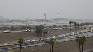
Rain comes down on Loop 202 in the East Valley on Friday, March 7, 2025. (ADOT Photo)
(ADOT Photo)
PHOENIX – A cold front brought widespread showers to metro Phoenix on Friday, making it the area’s wettest day in months.
The system started moving in from the west before 3 a.m. and left roads wet across much of the Valley within a few hours.
Phoenix Sky Harbor International Airport, which the National Weather Service (NWS) uses for the city’s officials readings, recorded 0.32 inches by 9:30 a.m. Some higher-elevation spots in the north and northeast Valley received a half-inch or more in the morning.
The daily airport total could end up as the highest since last spring. It’s already the wettest day since 0.33 inches fell on July 14, 2024.
If that mark is surpassed, Friday will become Phoenix’s wettest day since April 1, when 0.4 inches came down. The city received 0.5 inches on last year’s wettest day, March 31.
The record for Friday’s date, if you are wondering, is 0.71 inches from 2001.
“We’re just going to continue to see a widespread light-to-moderate rainfall throughout the Phoenix metro through most of this morning, and then it’ll kind of start to break up as we go into the afternoon hours,” NWS meteorologist Katherine Berislavich told KTAR News 92.3 FM.
The morning weather disturbance caused power outages at thousands of homes across the Valley and hundreds of flight delays.
Rain totals could increase on Phoenix’s wettest day in months
After a midday break, more rain is expected later in the day.
“We’re still not going to be done with rain chances as we head into the afternoon and evening hours,” Berislavich said. “And with the activity this afternoon and evening, we could even see some isolated thunderstorms and maybe some small hail associated with those storms as well.”
After the widespread rainfall exits later this morning additional scattered shower activity will be likely this afternoon & evening. Isolated thunderstorms & small hail will be possible with this activity. The higher terrain to the east will see rain transition to snow. #azwx pic.twitter.com/JRRxEuzERI
— NWS Phoenix (@NWSPhoenix) March 7, 2025
In addition, temperatures plunged from the low 60s to the upper 40s on Friday morning after the cold front hit.
“With all the rain and clouds today, we’re not expecting to warm up too much. Maybe up into the mid-to-upper 50s this afternoon,” Berislavich said.
What’s in the Valley forecast for the weekend and next week?
Looking ahead, Berislavich said the Valley will dry out and warm up over the weekend.
“We’ll be in the mid-to-upper 70s by Sunday. … On Monday, we’ll get back above normal and we’ll get into the low 80s,” she said.
However, more weather disturbances are in the forecast for next week, with the next rain expected to arrive Tuesday and another system due Thursday-Friday.
“A bit of an active pattern setting up for us,” Berislavich said.
The rain is more than welcome in the desert. Before Friday, Phoenix had received a mere 0.03 inches since late September.
KTAR News 92.3 FM’s Kate Ourada contributed to this report.
Related
 Weather knocks out power at thousands of Valley homes, impacts Sky Harbor flights
 KTAR Weather Center: Forecast, maps, latest news
 Rain chances, cooler temps heading to metro Phoenix as Hurricane Rachel moves north
 Snowbowl gets 2 inches of early-season snow
 Phoenix surpasses normal monsoon season rainfall total with late surge
 Thunderstorms create hazardous driving conditions across Phoenix area

Comments
0 Comments