
Rain cools off Phoenix area, higher elevations get snow
Rain and even hail hit parts of the Valley during morning rush hour Wednesday, while high elevations in northern and eastern Arizona experienced wintry conditions.

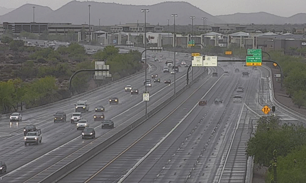
(Screen Shot/ADOT)
(Screen Shot/ADOT)
PHOENIX – Rain and even hail was reported in parts of the Valley during morning rush hour Wednesday, while high elevations in northern and eastern Arizona experienced wintry conditions.
According to the National Weather Service, the rain and clouds were expected to clear out by late morning. The forecast high for the Phoenix area was a comfortable 75 degrees under sunny skies.
The high Tuesday was 77 degrees, 13 degrees below average.
But this week’s cooling trend is coming to an end, with the forecast calling for a highs of 84 for Thursday and 95 for Friday.
Saturday could hit 101, which would be the hottest day of the year, and highs were forecast in the 100s through Tuesday.
855a: Decent storm moving through NE Phoenix. Earlier report of small hail near Cave Creek #azwx @CityofPhoenixAZ pic.twitter.com/tgFz0yizwu
— NWS Phoenix (@NWSPhoenix) May 2, 2018
@KTAR923 hailing huge at 40th street and union hills with lots of thunder…that’s a first for May
— Carol Baetzel (@cbprco) May 2, 2018
Meanwhile, parts of the state got a late taste of winter.
There was snow on the ground at the South Rim of the Grand Canyon and along sections of Interstate 40 near Ash Fork, while other routes in the region were wet from rain or snow that already melted.
National Weather Service statistics showed that Greer and the South Rim of the Grand Canyon each got six inches of snow by Wednesday morning.
Two inches of snow also fell at Alpine and McNary, Williams, Flagstaff and Pinetop-Lakeside all getting about an inch of snow.
However, most of the snow had melted by Wednesday afternoon.
A winter weather advisory in effect until 11 a.m. urged drivers to be prepared for snow-covered roads and limited visibility.
About 6 inches of wet, sticky, snow here at #GrandCanyon this 8 am 5/2/2018. Be careful, roads and footpaths are slippery. #WednesdayThoughts #Azwx #Arizona @NWSFlagstaff @ArizonaDOT pic.twitter.com/oNxPeS83RH
— Grand Canyon NPS (@GrandCanyonNPS) May 2, 2018
The Associated Press contributed to this report.
Related
 Firefighters preparing for increased activity with north-central Arizona fire
 WATCH: Andy Biggs, third-party candidates debate tonight as Governor Hobbs sits out
 Maricopa County supervisor calls for inquiry into recorder’s claim of Phoenix mail facility closure
 Arizona drug trafficker caught with 75 pounds of fentanyl sentenced to 7 years
 Sine Kerr calls John Giles’ debate absence ‘absolutely disgraceful’
 Child killed in multivehicle crash on I-10 in Phoenix

Comments
0 Comments