
Potential rain accompanies more excessive heat for metro Phoenix
An excessive heat warning is in effect for south-central and southwestern portions of Arizona through Wednesday, but there is some potential for rain.


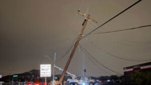
(Facebook Photo)
(Facebook Photo)
PHOENIX – While the excessive heat will continue in metro Phoenix this week, there’s also an increased chance of isolated thunderstorms.
The Valley got a glimmer of the monsoon Sunday and could see similar conditions on Monday with strong winds, blowing dust, hail and rain capable of producing flash floods, according to the National Weather Service.
With a very similar pattern in place today, we expect things to play out very similar to how they did yesterday. Storms that develop may contain strong/severe winds, blowing dust, small hail, and heavy rain capable of producing flash flooding. #azwx #cawx pic.twitter.com/0VW1Z24ZaR
— NWS Phoenix (@NWSPhoenix) August 17, 2020
The south central and southwest portions of the state have the best chance for rainfall, and those chances will continue throughout the week.
Despite the opportunity for August showers, an excessive heat warning is in effect through Thursday at 8 p.m. for south central and southwest portions of Arizona.
Monday was forecasted to reach 114 degrees. Temperatures are expected to climb to 112 degrees on Tuesday and 113 degrees on Wednesday.
During periods of extreme heat, experts advise people to stay hydrated, limit the amount of time outside, try to stay inside air conditioned buildings and remember to check on elderly family members and neighbors.
People are also advised to watch for warning signs of heat-related illnesses, which can include heavy sweating, muscle cramps, weakness, headache and nausea.
Related
 Phoenix sets record daily temperature at 115 degrees
 Phoenix-area dust storm warning in effect, multiple highways impacted
 Your guide to Arizona’s 2026 general election debates: Candidates face off in top races
 2026 Cactus League season creates record $806.9 million in total economic activity
 Sen. Ruben Gallego says Republicans lack empathy about economic pain
 About 5,600 APS customers lose power in thunderstorms

Comments
0 Comments